Atm nearby Pillér Takarékszövetkezet ATM
Coronavirus disease (COVID-19) Situation
confirmed cases
2230232
deaths
49048
Hungary
Atm nearby Pillér Takarékszövetkezet ATM
Pillér Takarékszövetkezet ATM
23, Retek utca, 6723, Szeged, HU Magyarország
contacts phone
:
+36
Latitude:
46.2670501
, Longitude:
20.1591825
larger map & directions
read more
nearest Atm
Pillar Credit Union ATM
Szeged, Retek utca 23
Atm
read more
59 m
OTP ATM
Szeged, Retek utca 18
Atm
read more
531 m
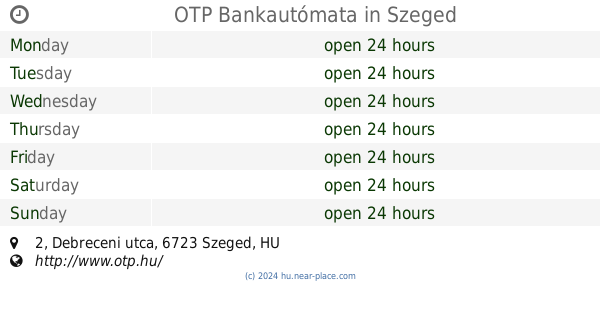
OTP Bankautómata
Szeged, Debreceni utca 2
Atm
read more
531 m
OTP ATM
Szeged, Debreceni utca 2
Atm
read more
614 m
OTP ATM
Szeged, Makkosházi körút 7
Atm
read more
634 m
OTP ATM
Szeged, Budapesti körút 5
Atm
read more
758 m
OTP Bankautomata
Szeged, Sárosi utca
Atm
read more
776 m
CIB Bank ATM
Szeged, Makkosházi körút 21
Atm
read more
877 m
K&H ATM - ABC
Szeged, Makkosházi körút
Atm
read more
1.18 km
FHB Bank ATM
Szeged
Atm
read more
1.49 km
OTP ATM
Szeged, Takaréktár utca 7
Atm
read more
1.524 km
Erste Bank ATM
Szeged, Tisza Lajos körút 41
Atm
read more
1.549 km
UniCredit ATM
Szeged, Kossuth Lajos sugárút 18-20
Atm
read more
1.575 km
Erste ATM
Szeged, Rákóczi tér 2
Atm
read more
1.587 km
K&H ATM - Szeged Tesco
Szeged, Rókusi körút 42
Atm
read more
1.624 km
OTP ATM
Szeged, Rókusi körút 62
Atm
read more
1.624 km
OTP Bankautomata
Szeged, Rókusi körút 62
Atm
read more
1.686 km
Otp ATM
Szeged, Tisza Lajos körút 47-49
Atm
read more
1.714 km
K&H ATM
Szeged, Mars tér 1-3
Atm
read more
1.794 km
Erste Bank ATM
Szeged, Torontál tér 1
Atm
read more
1.803 km
Erste Bank ATM
Szeged, Széchenyi tér 17
Atm
read more
1.938 km
Pillér Takarékszövetkezet ATM
Szeged, Oroszlán utca 1
Atm
read more
1.985 km
Erste Bank ATM
Szeged, Kölcsey utca 13
Atm
read more
2.11 km
OTP Bank Atm
Szeged, Londoni körút 3
Atm
read more
2.209 km
MKB Bank ATM
Szeged, Londoni körút 3
Atm
read more
📑
all categories
Accounting
Administrative area level 1
Administrative area level 2
Airport
Amusement park
Aquarium
Art gallery
Atm
Bakery
Bank
Bar
Beauty salon
Bicycle store
Book store
Bowling alley
Bus station
Cafe
Campground
Car dealer
Car rental
Car repair
Car wash
Casino
Cemetery
Church
City hall
Clothing store
Colloquial area
Convenience store
Country
Courthouse
Dentist
Department store
Doctor
Electrician
Electronics store
Embassy
Finance
Fire station
Florist
Food
Funeral home
Furniture store
Gas station
General contractor
Grocery or supermarket
Gym
Hair care
Hardware store
Health
Hindu Temple
Home goods store
Hospital
Insurance agency
Intersection
Jewelry store
Laundry
Lawyer
Library
Light rail station
Liquor store
Local government office
Locality
Locksmith
Lodging
Meal delivery
Meal takeaway
Mosque
Movie rental
Movie theater
Moving company
Museum
Natural feature
Neighborhood
Night club
Painter
Park
Parking
Pet store
Pharmacy
Physiotherapist
Place of worship
Plumber
Point of interest
Police
Political
Post office
Premise
Real estate agency
Restaurant
Roofing contractor
Route
Rv park, camping
School
Shoe store
Shopping mall
Spa
Stadium
Storage
Store
Subpremise
Subway station
Supermarket
Synagogue
Taxi stand
Train station
Transit station
Travel agency
University
Veterinary care
Zoo
administrative area level 3
sublocality level 1
↑